
Kootenay National Park
Quick Navigation
Kootenay National Park is located in the southeast corner of Alberta, Canada. The park covers an area of 543 square miles (1,406 sq km) and is one of Canada’s most popular national parks.
The park is part of the larger Canadian Rocky Mountain Parks World Heritage Site which includes Banff National Park and Jasper National Park in Alberta and Yoho National Park in British Columbia along with three other neighboring provincial parks in British Columbia.
Kootenay is a land of extreme wilderness comprised of mountains, deep canyons, towering waterfalls, meandering rivers, and forests that blanket the area. The Canadian Park Service describes Kootenay as “a place of unique contrasts, from icy mountain rivers to steamy hot springs.”
Much of the park is accounted for by the Canadian Rockies as well as parts of the Kootenay and Park mountain ranges. Deltaform Mountain is the highest summit in the park at 11,234 feet (3,102 m) with elevations dropping down to 3,012 feet (918 m) in the valley of the southwestern entrance into the park.
The lower elevations feature a montane spruce ecosystem with Douglas fir, lodgepole pine, trembling poplar, and western red cedar. The higher elevations are dominated by Englemann spruce and subalpine fir.
The grizzly bear and black bear are probably the most exciting wildlife sightings, however, the ungulates account for the majority of larger species that you might see including bighorn sheep, moose, mountain goat, mule deer, red deer, and white-tailed deer. Some of the predator species include badger, bobcat, cougar, lynx, timber wolf, and wolverine.
The park is not known for bird species with only 32 species calling the park home. The rest of the wildlife and wilderness is what draws most people to explore Kootenay National Park.
Photos


Highlights
The diversity and extreme nature and contrasts of the park make almost any exploration a highlight. However, some of the most favored attractions include Deltaform Mountain, Radium Hot Springs, Marble Canyon, and the Paint Pots.
Radium Hot Springs
Radium Hot Springs is a quaint village on the skirts of the national park. There are just over 770 residents living in the town. The town is used as the primary access point to the hot springs located in the park.
The hot springs vary in temperatures ranging from 95 to 117oF (35 to 47oC). Some look for therapeutic enhancements while others just like relaxation. It attracts both the locals and visitors who want to taste nature's natural heaven.
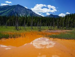 Paint Pots
The Paint Pots is a mineral spring featuring acidic cold water. The deposits contain iron oxide and other minerals that cause the water to turn reddish, with shades of yellow and brown mixed in. There are 14 species of algae living amongst the paint pots adding color to the character of the landscape.
Marble Canyon
Tokumm Creek runs through Marble Canyon located on the north side of the park. The canyon and the forested area around the creek are surrounded by stunning mountains that create astounding backdrops to this impressive landscape. This also gives way to the neighboring Huma Falls further downstream where the creek merges with the Vermilion River.
Kootenay National Park Trails
Hiking is one of the favored ways to explore all that Kootenay has to offer. There is an abundant number of trails that can be accessed in many different places throughout the park. There are easy, moderate, and difficult rated trails giving everyone a chance to discover and explore the wildlife and wilderness.
Kootenay Highlights
- Deltaform Mountain
- Radium Hot Springs
- Marble Canyon
- Paint Pots
Park Map
Sources
- All Trails, Best Trails in Kootenay National Park, https://www.alltrails.com/parks/canada/british-columbia/kootenay-national-park, retrieved June 2020.
- Canada Parks Canada, Kootenay National Park, https://www.pc.gc.ca/en/pn-np/bc/kootenay, retrieved June 2020.
- Britannica, Kootenay National Park, https://www.britannica.com/place/Kootenay-National-Park, retrieved June 2020.
- Kootenay Rockies, Kootenay National Park, https://www.kootenayrockies.com/partner/kootenay-national-park/, retrieved June 2020.
- National Geographic, National Parks of North America, Canada-United States-Mexico, National Geographic Society, 1995.
- The Canadian Encyclopedia, Kootenay Lake, https://www.thecanadianencyclopedia.ca/en/article/kootenay-lake, retrieved June 2020.
- The Canadian Encyclopedia, Kootenay National Park, https://thecanadianencyclopedia.ca/en/article/kootenay-national-park, retrieved June 2020.
- UNESCO, Canadian Rocky Mountain Parks, https://whc.unesco.org/en/list/304/, retrieved June 2020.