
Quick Navigation
Cradle Mountain Lake St. Clair National Park is located on the island state of Tasmania northwest of Hobart in southern Australia. The national park area encompasses an area of 623.3 square miles (1,614.43 sq km).
The mountainous area includes the summit of Cradle Mountain, Mount Oakleigh, Mount Ossa, Mount Pelion East, Mount Pelion West, and Barn Bluff. Lake St. Clair is located in the southern region of the park. The lake and Cradle Mountain serve as the inspiration for the name of the national park.
Over half of the vegetation and alpine flora is endemic to the area. Almost 70% of the rainforest found on the island of Tasmania is accounted for within the national park boundaries.
The renowned Tasmanian devil calls the park home. There are a variety of other popular Australian species found in the national park which include platypuses, wombats, wallabies, currawongs, and echidnas. There are an additional 11 endemic bird species here as well.
The endemic bird species has led to the park receiving accolades as an Important Bird Area (IBA) within the country of Australia.
Photos


Highlights
The mountain landscape and terrain featuring Cradle Mountain and neighboring peaks are an immediate draw to the park. Lake St. Clair provides spectacular lake landscapes surrounded by the higher elevation summits as well.
Experiencing the Tasmanian devil and other popular Australian species is the desired sighting for most tourists as well.
 Cradle Mountain
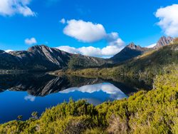
Cradle Mountain reaches a summit of 5,069 feet (1,545 m) making it the sixth-highest mountain in Tasmania. One of the most remarkable views of the mountain occurs from across Dove Lake. The view across the lake with Cradle Mountain as the backdrop is picturesque. The peak can be reached by hikers relatively easy; the journey takes about 6.5 hours.
There are four summits on the mountain including the highest point called Cradle Mountain followed by Smithies Peak at 5,010 feet (1,527 m), Weindorfers Towers at 4,787 feet (1,459 m), and the Little Horn at 4,446 feet (1,355 m).
Lake St. Clair
Lake St. Clair is the deepest lake in Austalia reaching a depth of 700 feet (215 m). The lake covers an area of 11 square miles (28 sq km). The lake sits at an elevation of 2,417 feet (737 m) above sea level.
Cradle Mountain-Lake St. Clair Trails
There are a number of hikes that explore the mountain and name-sake lake. Other trails let you experience other facets of nature the park has to offer. You are encouraged to get out and explore this wonderful landscape.
Park Protection
Cradle Mountain Lake St. Clair National Park was established as a protected area to protect the captivating landscapes for future generations. The park is a temendous place for citizens and global visitors to experience some of the best natural settings that Tasmania has to offer. The park also protects the habitat for 11 endemic bird species.
Cradle Mountain-Lake St. Clair Highlights
- Cradle Mountain
- Lake St. Clair
Park Map
Sources
- Australia, Cradle Mountain Lake St. Clair National Park, https://www.australia.com/en-us/places/hobart-and-surrounds/guide-to-cradle-mountain-lake-st-clair-national-park.html, retrieved October 2019.
- Britannica, Cradle Mountain, https://www.britannica.com/place/Cradle-Mountain, retrieved June 2020.
- Britannica, Lake Saint Claire, https://www.britannica.com/place/Lake-Saint-Clair-lake-Tasmania-Australia, retrieved June 2020.
- Discover Tasmania, Cradle Mountain St. Clair National Park, https://www.discovertasmania.com.au/about/national-parks-and-wilderness/cradle-mountain-lake-st-clair-national-park, retrieved October 2019.
- Parks & Wildlife Service Tasmania, Cradle Mountain, https://www.parks.tas.gov.au/?base=3297, retrieved October 2019.
- Wild Sight, Day Walks: Cradle Mountain-Lake St Clair, https://wildsight.com.au/cradle-mountain-lake-st-clair/, retrieved October 2019.